
Auckland
At
13°C
- Sunrise:
- Sunset:
Fine. Southerlies.
Mainly fine with some passing cloud. Southeasterlies.
Fine. Easterlies.
For more detailed weather information visit MetService.
Marine Recreational Forecasts - Auckland
Area Description:
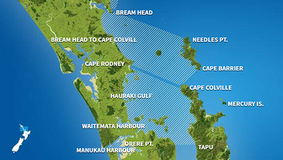
Bream Head to Cape Colville, Hauraki Gulf, Waitematā Harbour, Manukau Harbour
Situation:
A ridge of high pressure builds over the South Island today, while a southerly flow affects the North Island. Tomorrow, the ridge extends over the rest of the country, and a southeast flow covers the North Island. On Tuesday a ridge of high pressure over New Zealand starts to weaken, while a front approaches from the Tasman Sea, bringing northeasterlies to the South Island. On Wednesday, the front moves onto the country. On Thursday, the front crosses New Zealand, with a northwest flow spreading over the country behind it. On Friday, a large trough of low pressure from over the Tasman Sea moves onto New Zealand.
Warnings:
Forecasts:
For Bream Head to Cape Colville: Today: Southerly 15 knots, turning southeast 15 knots in the evening. Sea slight. Fine. Easterly swell 1 metre. For Hauraki Gulf: Today: Southerly 15 knots, turning southeast 15 knots in the evening. Sea slight. Fine. For Waitematā Harbour: Today: Southerly 10 knots, turning southeast 10 knots in the evening. Sea slight. Fine. For Manukau Harbour: Today: Southerly 10 knots, turning southeast 10 knots in the evening. Sea slight. Fine. For the west coast: Southwest swell 2 metres, easing to 1 metre.
Outlook:
For Bream Head to Cape Colville: Monday: Southeast 15 knots, easing to 10 knots in the morning. Sea slight. Partly cloudy. Easterly swell 1 metre. Tuesday: Easterly 10 knots. Partly cloudy. Easterly swell 1 metre. Wednesday: Easterly 10 knots, turning northerly 15 knots early. Cloudy. Easterly swell 1 metre. Thursday: Northerly 15 knots. Occasional rain, clearing. Northeast swell 1 metre. For Hauraki Gulf: Monday: Southeast 15 knots, easing to 10 knots in the morning. Sea slight. Partly cloudy. Tuesday: Easterly 10 knots. Partly cloudy. Wednesday: Easterly 10 knots, turning northerly 15 knots early. Low cloud and drizzle developing. Thursday: Northerly 15 knots. Occasional rain, clearing. For Waitematā Harbour: Monday: Southeast 10 knots, easing to variable 5 knots for a time in the afternoon and early evening. Sea slight. Partly cloudy. Tuesday: Easterly 10 knots. Partly cloudy. Wednesday: Northeast 15 knots. Low cloud and drizzle developing. Thursday: Northeast 15 knots. Showers, clearing. For Manukau Harbour: Monday: Southeast 10 knots, easing to variable 5 knots in the afternoon. Sea slight. Partly cloudy. For the west coast: Southwest swell 1 metre. Tuesday: Variable 5 knots, becoming easterly 10 knots in the morning. Partly cloudy. For the west coast: Southwest swell 1 metre. Wednesday: Northeast 15 knots. Low cloud and drizzle developing. For the west coast: Westerly swell 1 metre developing. Thursday: Northeast 10 knots. Low cloud and drizzle, turning showers. For the west coast: Westerly swell 1 metre.
Swell:
Marine Coastal Forecasts - Colville
Forecast:
Sunday: Southerly 15 knots. Sea slight. Northerly swell 1 metre, easing. Easterly swell 1 metre.
Outlook:
Outlook following 3 days: Monday: Southeast 15 knots. Sea slight. Easterly swell 1 metre. Tuesday: Easterly 10 knots. Moderate easterly swell. Wednesday: Easterly 10 knots, turning northerly 15 knots early. Moderate easterly swell. Thursday: Northerly 20 knots. Moderate easterly swell.
Marine Coastal Forecasts - Raglan
Forecast:
Sunday: Southeast 20 knots. Sea moderate. Long period southwest swell 2 metres, easing. Northwest swell 2 metres, easing.
Outlook:
Outlook following 3 days: Monday: Southeast 15 knots, easing to variable 10 knots in the afternoon. Easterly 15 knots developing late evening. Sea slight. Long period southwest swell 1 metre. Tuesday: Northeast 15 knots. Wednesday: Northeast 15 knots, rising to 25 knots early. Easing to northerly 15 knots late. Sea becoming rough for a time. Moderate northwest swell developing. Thursday: Northerly 15 knots. Moderate northwest swell easing.